
- Forge River Watershed Plan
- The Incorporated Village of Malverne
- Pathogen Load Assessment
- Sanitary Sewer System GIS
- Tidal Wetlands Trends Analysis
Forge River Watershed Plan
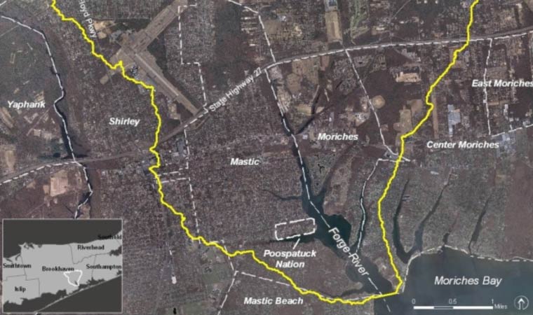
Mastic, Shirley and Vicinity, NY
Show Project Details
Decades of nitrogen inputs from commercial duck farming, residential and agricultural fertilizer use, and thousands of on-site wastewater treatment systems (septic systems) severely degraded the Forge River. Algae blooms caused low oxygen conditions that led to fish kills and problem odors.
A comprehensive assessment of existing conditions was prepared from research studies and an extensive water quality and sediment analysis data set. Nitrogen inputs from local duck farms and on-site sanitary systems (the largest nitrogen inputs), fertilizer use, atmospheric deposition, sediment flux, and other sources were quantified for each sub-drainage area using GIS analyses. Regulatory and programmatic considerations were documented and a Total Maximum Daily Load (TMDL) Request for Proposals prepared for nitrogen TMDL modeling to follow this study. The project was led by a 30-member steering committee and stakeholders were kept engaged through public workshops and a web-based information initiative.
Cameron Engineering identified Forge River problems as those of a typical older coastal community – a legacy of high nitrogen contributions to groundwater from agricultural and residential fertilizers and on-site wastewater system effluent ultimately discharged to surface waters. A set of 62 short-, mid-, and long-term management strategies were recommended for the Forge River groundwater contributing area and prioritized according to the subwatershed. They included: land use controls; protection of critical habitats and restoration of coastal wetlands; fertilizer use restrictions; requirements for on-site system upgrades and regular maintenance; sewage collection, treatment and disposal for selected areas; and long-term dredging. Additional research and data collection were recommended along with training, education, and stewardship programs.
Although the Forge River was studied since the early 1950s, this effort was the first to identify all of the issues and establish a quantitative water quality prioritization for each of the 14 subwatersheds. The short-, mid-, and long-term strategies reflected lower, moderate, and higher costs, respectively. The strategies were prioritized according to their potential for achieving water quality improvements for the Forge River with the following parenthetical weightings: water quality benefits (4), cost (3), acceptance by the public (2), and technical and legal implementation difficulty (1). Specific actions and responsible parties were clearly defined. Study recommendations will enable the Town and County to move forward immediately with actions to improve conditions in the Forge River today. Most of the solutions proposed could be applied to the many other coastal communities whose bays and harbors have been similarly degraded.
This project received the ACEC NY 2013 Platinum Award for Engineering Excellence.
New Zoning Map and GIS Tax Parcel Database Revisions
Malverne, NY
Show Project Details
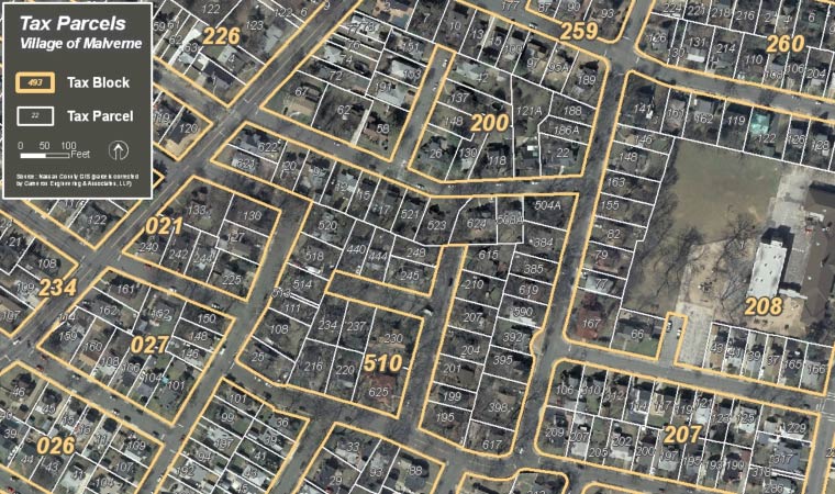
The Incorporated Village of Malverne, New York, commissioned Cameron Engineering to prepare a new zoning map and to revise its existing tax parcels data layer. The current zoning map was produced many years ago by mechanical drafting means and cannot be easily duplicated for publication and distribution purposes.
Cameron Engineering produced the new zoning map with a Geographic Information System (GIS). Zone boundaries were established along tax parcel and block boundaries in our GIS. Prior to delineating the zones, Cameron Engineering corrected approximately 3,300 tax parcel boundaries to known reference points and eliminated numerous parcel gaps, overlaps and other misalignments. This effort produced a highly accurate zoning map which can be used confidently by Village boards and the general public. The new zoning map will feature a street directory with locator grid and will be produced in two versions: a color version for wall mounting and a black-and-white version for photocopying and distribution.
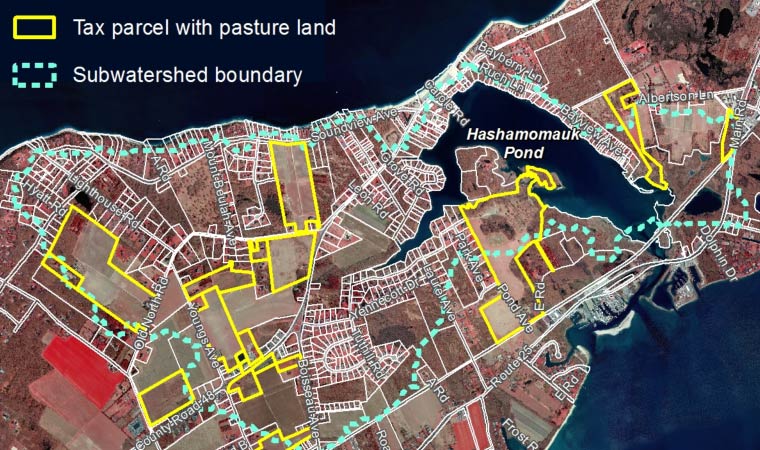
Peconic Estuary Pathogen Load Assessment
Suffolk County, NY
Show Project Details
Cameron Engineering conducted a study of pathogen loading in four sub-watersheds of the Peconic Bay for the Suffolk County Peconic Estuary Program. The primary purpose of the project was to survey seasonal waterfowl populations (i.e., Canada geese and mute swans) in order to estimate pathogen loadings. The team also estimated, through secondary data sources, pathogen loads from other wildlife, livestock, pets and septic systems. Key features of the project included the use of spatial analysis (i.e, with GIS data sets) and spectral analysis of color-infrared imagery to identify geese and swan habitat and to extrapolate total waterfowl population based on comparable habitats. The team also provided recommendations for wildlife management and the mitigation of impacts from on-site wastewater systems.
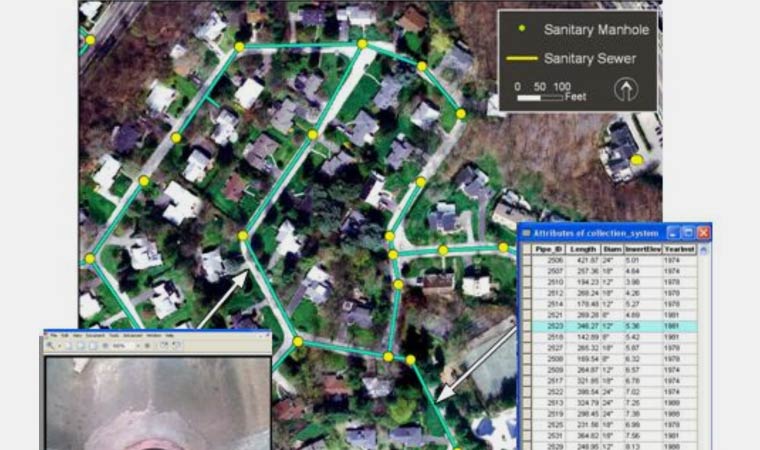
Sanitary Sewer System GIS and Digital Video Conversion
Roslyn, NY
Show Project Details
The Roslyn Department of Public Works (DPW) used their GIS for organizing, accessing and manipulating all of the information about their sanitary sewer system. Stacks of reports, rolls of maps and boxes of video tapes was converted into digital format and stored on the Village server. Data on the characteristics and condition of any of the sewer system’s components was accessible through the DPW GIS with just a few mouse clicks.
Cameron Engineering provided GIS development and sewer video conversion services for the project. Closed-circuit television (CCTV) videos of the sewer system were converted into a digital video format. Manhole-to-manhole portions of the standard two-hour sewer videos were digitally clipped and hyperlinked to the appropriate pipe segment within the sewer system GIS. Customer connections were also located along each pipe segment – via a CCTV travel distance counter – and modeled in the DPW GIS. Key data for each sewer manhole, pipe segment and customer connection were also recorded in the DPW GIS. The DPW utilizes their sewer system GIS for responding to emergencies, keeping track of system changes and planning future improvements.
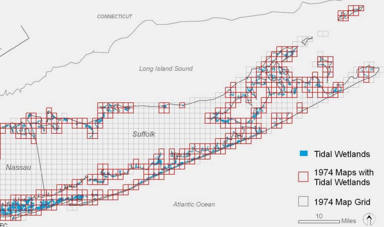
Long Island Tidal Wetlands Trends Analysis and
Wetlands Loss Characterization Matrix
Long Island, NY
Show Project Details
Long Island tidal wetlands were under stress from a number of factors including population growth and coastal land development, poor or declining water quality, invasive plants and sea-level rise. The Cameron Engineering- Land Use Ecological Services Team understands the urgent need to estimate tidal wetland loss and understand the factors contributing factors to these processes. The team will employ digital image processing, groundtruthing, photo interpretation and reference mapping techniques to delineate Long Island’s existing tidal wetlands and enhance the official 1974 delineations. Tidal wetland trends were summarized in both graphic and tabular form for the entire study area, for each estuarine system and for each marsh complex. Historical data for environmental indicators and a variety of geographic databases were utilized – in concert with the wetland delineations – to construct a Marsh Loss Characterization Matrix. A project report was prepared that summarizes the mapping methodology, the trends analysis and its findings and the development and utilization of the Marsh Loss Characterization Matrix.
The first project goal was to understand the quantitative and qualitative changes in the tidal wetlands of the study area. Through a trends analysis, the team established the extent of marsh loss or gain and the changes in their features and vegetation. The trends analysis was based on the team’s development of an accurate spatio-temporal model of the tidal wetlands to facilitate a comparison of wetlands in 1974 to those of the present (2005 and 2008). Key objectives included correcting the spatial distortions and inaccuracies in the 1974 tidal wetland mapping and broadening its classifications to include Phragmites, marsh pannes, ponds, marsh channels, and mosquito ditches. To establish current conditions, the project team compiled and corrected (where necessary) the 2005 and 2008 color-infrared imagery and delineate the broadened tidal wetland categories through photointerpretation.
The second project goal was to develop an analytical tool for determining the specific stressors of “at-risk” tidal wetland complexes. A Marsh Loss Characterization Matrix was developed from the tidal wetlands trends analysis, field-collected data, historic documents, and scientific research for specific, pilot marsh complexes. A key objective in the development of the Marsh Loss Characterization Matrix was ensuring its broad applicability to wetland complexes throughout the study area. A properly developed matrix was an invaluable analytical tool in the development of management plans for marsh stabilization and restoration.