
Planning
Cameron Engineering and Associates, LLP provides comprehensive planning services to municipal and private clients. We provide innovative solutions and coordinate resolution of planning and environmental concerns with engineering services to assure complete coverage of project requirements.
The Firm specializes in the preparation of a comprehensive range of planning, land use, and feasibility studies; site development plans; zoning maps, codes, and ordinances; and coastal assessment and consistency certifications.
Cameron Engineering has excellent success in obtaining regulatory permits. We have obtained numerous permits and approvals for transfer stations, recycling facilities, landfills, composting facilities, and combination facilities. Our Firm also has expertise in obtaining permits issued by the New York State Department of Environmental Coordination and the U.S. Army Corps of Engineers under various other programs including freshwater and tidal wetlands and wild, scenic, and recreational rivers. Our permitting services also include federal and local permits that may be required for marine and freshwater projects.
Included in the range of our Firm’s planning services are:
Continue Reading
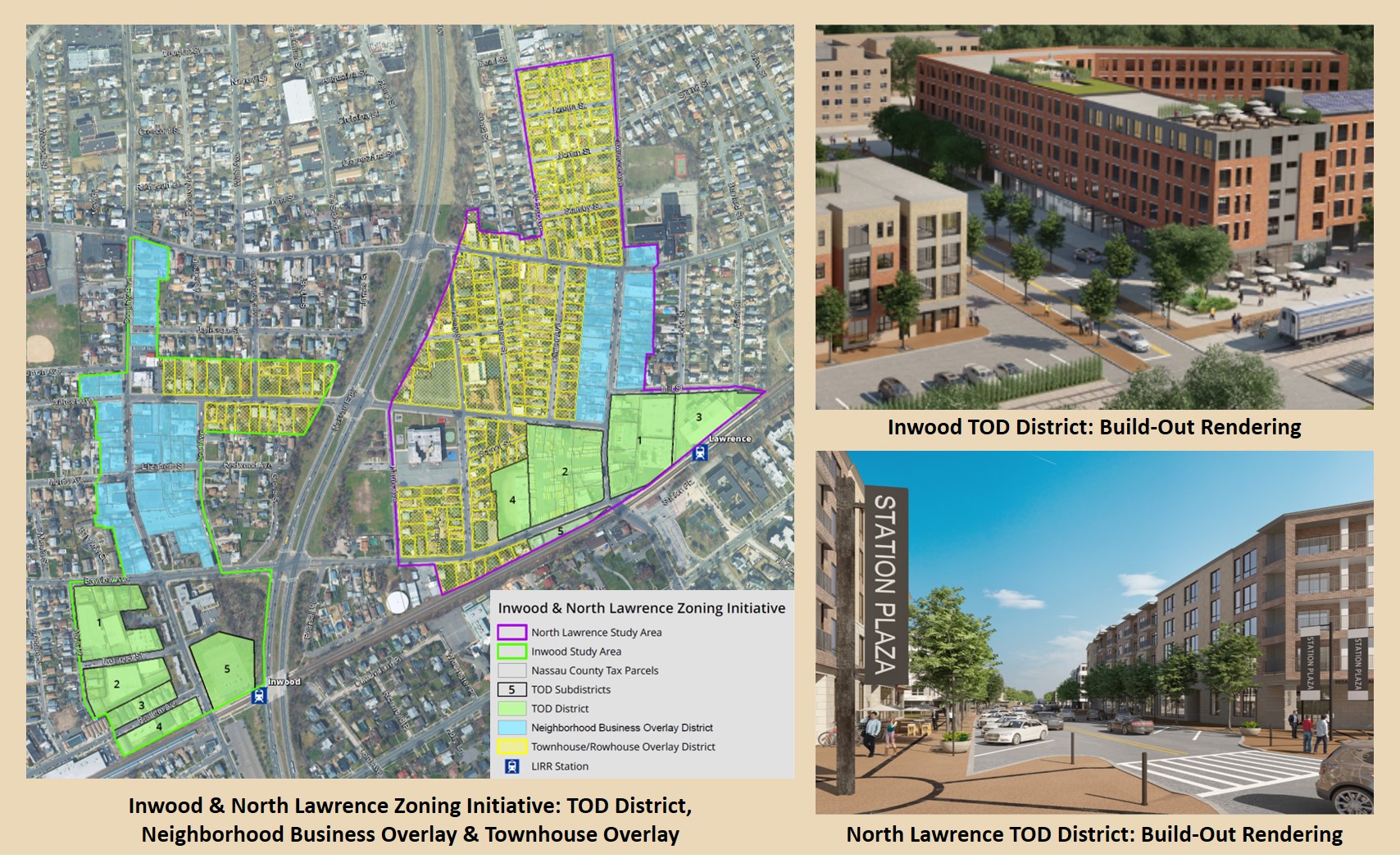
- Master Plans/Comprehensive Plans
- Land Use and Planning Studies
- Downton Revitalization Plans
- Community Resiliency Plans
- Land Development Feasibility Studies
- Municipal Land Use Board Services (Planning Boards; Boards of Appeals)
- Zoning Analysis/Code Revisions
- Coastal Assessment/Consistency Certifications
- Local Waterfront Revitalization Programs
- Wetlands Restoration and Wetlands Permits
- Traffic, Circulation, and Parking Analyses
- Solid Waste Management Facility Permits
- State Pollutant Discharge Elimination System (SPEDES) Permitting
- Recycling Programs
- Environmental/Green Infrastructure Engineering
- Grant Applications
Environmental Impact Assessment
Cameron Engineering is well-versed in all aspects of federal, state, and local environmental review processes, serving as a consultant to both municipalities and private clients throughout the New York Metropolitan area.
Our firm’s environmental practitioners are well-versed in both the technical and procedural components of environmental review requirements. The Firm has prepared environmental review documents for many municipal and private applications, often as a component of a larger planning study, land development project, or engineering design project.
Representative environmental review experience includes preparation of environmental documentation to support projects subject to federal, state, and city environmental quality review procedures. The scope of our environmental review services includes:
Continue Reading
National Environmental Policy Act (NEPA)
- Environmental Assessments (EAs)
- Environmental Impact Statements (EISs)
- Categorical Exclusions (CEs)
- Alternative Analyses
- Agency coordination
- Public review
State Environmental Quality Review (SEQR)
- Environmental Assessment Forms (EAFs)
- Environmental Impact Statements (EISs)
- Alternatives Analyses
- Agency coordination
- Public review
City Environmental Quality Review (CEQR)
- Environmental Assessment Statements (EASs)
- Environmental Impact Statements (EISs)
- Agency coordination
- Public review
- New York City Uniform Land Use Review Procedure (ULURP) coordination
Geographic Information Systems
GIS has become an integral and indispensable tool for planning and analysis, offering remarkable utility for land use, environmental, and infrastructure applications. As a full-service firm, Cameron Engineering provides a wide range of GIS capabilities to meet our clients’ needs. From the preparation of alternative land use scenarios to the spatial analysis of their environmental impacts, Cameron Engineering has the skills and knowledge to apply GIS techology to solve challenging problems and provide critical information to decision-makers in private, public, and institutional settings.
Continue Reading
Cameron Engineering offers a host of GIS and related services including the following:
GIS Database Development – Our expertise, software, and equipment enable us to offer an extensive menu of spatial data compilation techniques, including the scanning and conversion of paper maps and photo- interpretation of orthoimagery. We collect and organize a wide range of spatial data based on a carefully prepared GIS data dictionary. Real-world features are geographically referenced according to the highest standards for positional accuracy.
GPS Collection of Features – Cameron Engineering utilizes GPS (Global Positioning Systems) technology to locate infrastructure assets such as those depicted here to sub-foot accuracy. Assets located with a GPS receiver are easily incorporated into GIS databases to construct comprehensive infrastructure inventories. GPS receivers may also be employed to delineate environmental features such as wetlands, surface water, forest canopies, and shorelines.
Spatial Analysis – Cameron Engineering GIS specializes in the spatial analysis of complex problems including site suitability, site selection and environmental review. To support GIS analyses and modeling, our extensive GIS library comprises numerous spatial data sets.
Asset Management – Asset management systems employ the powerful visualization and spatial analysis capabilities of GIS along with a versatile suite of database applications geared specifically toward managing infrastructure and utilities. An asset management system provides the following ability:
- Centralize all system information within one application
- Coordinate work for field surveys/investigations, repairs, and maintenance
- Track customer calls and complaints
- Plan upgrades and replacements
- Automate official reporting on value and condition of assets
Asset management systems are employed across a wide range of infrastructures and utilities, including water supply, drainage, sanitary, lighting, traffic control, signage and systems. Whatever the application, Cameron Engineering can provide a customized application to maximize GIS investment and optimize operations and maintenance.
3-D Visualization – Cameron Engineering offers 3-D visualization and analysis. Whether our clients need to understand the visual impacts of alternative development scenarios or the shadowing of proposed buildings, we have the tools, data, and object libraries to prepare accurate and realistic models. 3-D simulations are ideal for a variety of analyses including:
- Zoning Change Impact
- Development Proposals
- Downtown Revitalization Plans
- Visual Impact Analysis
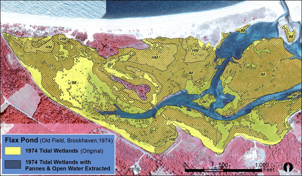
Remote Sensing and Land Use/Land Cover – Cameron Engineering has the capability to create land cover and land use maps from multispectral images such as those from the Landsat, ASTER, EO-1 and MODIS satellites. Remote sensing uses the variation in spectral signatures among different types of land cover – including visible, infrared and thermal wavelengths – to classify land cover into standard or client-designated categories. Remote sensing analysis is useful for a wide range of analyses and mapping applications including:
- Change analysis (land use/land cover)
- Conservation planning/habitat protection
- Freshwater and tidal wetlands
- Natural resource mapping
- Coastal zone studies
Contact the Partners in Charge
Michael Keane, AICP – Email: mkeane@cameronengineering.com
Sarah Oral, PE, LEED AP BD+C – Email: soral@cameronengineering.com